Karabakh
Karabakh is one of the oldest historical regions of Azerbaijan. The word "Karabakh", which the Azerbaijani people called the part of their native land, as mentioned in the original sources 1300 years ago (from the 7th century).
Nagorno-Karabakh is an integral part of the Republic of Azerbaijan, located in the western part of the Republic of Azerbaijan, which was historically the part of the Caucasus Albania (Arran), the Karabakh Khanate, the Azerbaijan Democratic Republic, the Azerbaijan Soviet Republic. The region has been one of the areas where Armenians have been resettled to Azerbaijan since 1820.
The history of the formation of "Karabakh" as the name of a specific region, the region of Azerbaijan allows explaining its etymology in a more scientific form, because in the Azerbaijani language (as well as in other Turkic languages) the word "gara", in addition to designating a color, also has other meanings: “Dense”, “impassable”, “large”, “dark”, etc. From this point of view, the term Karabakh acquires such meanings as: “dark garden”, “large garden”, “dense garden”, “impassable garden”, “ picturesque garden ”, etc. Thus, like Karabakh itself, the word“Karabakh ”also belongs to the Azerbaijani people.
Polemising about Karabakh, from the very beginning, the following question arises: Where is Karabakh located, what territories of Azerbaijan does it cover? The answer to this question is even more relevant today and is important for understanding the “Nagorno-Karabakh problem” created by the Armenian separatists. To answer the question posed, let's turn to the original source. Mirza Jamal Javanshir, being the vizier of the “Karabakh Khanate”, which is an Azerbaijani state and once covered this territory, arguing about this issue in his work “History of Karabakh” (1847) wrote: “The borders of the Karabakh region, according to ancient historical books, are as follows: the southern side from the Khudaverin bridge to the Synyk bridge is the Araz river. Now the Synyk bridge is located between the Kazakh, Shamsaddin, and Demirchi-Hasanli jamaats (regions), and the officials of the Russian state call it the Red Bridge in the Russian interpretation, i.e. Golden Bridge. On the east side is the Kura River, which in the village of Javad, merging with the Araz River, then flows into the Caspian Sea. From the northern side to the Kura River, which is the border with Elizavetpol, the border of the region is the Choran River, and the Kura River in many places (flowing) reaches the Araz River. On the western side, there are peaked Karabakh mountains with peaks called Kushbek, Salverty and Arikli ”.
Such an accurate representation of the territory and borders of Karabakh in the initial period of occupation and colonization by Russia is explained by the fact that:
1) a representative of the state who is directly involved in the "management of Karabakh" writes about this fact, in other words, this fact is an official word based on official documents, an official word of a state official in the service of Russia; 2) on the other hand, this fact has survived, not only based on reality and practice, it is also confirmed by primary sources. To confirm the point of view of Mirza Jamal, the use of references to ancient historical books is not accidental.
As you can see, being a political-geographical space, in history, there has always been a concept not "Nagorno-Karabakh", but a concept covering the entire territory of Karabakh as a whole - mountains, plains - the general concept of "Karabakh". The truth is this: today in Azerbaijan there is both Nagorno-Karabakh and Lowland Karabakh (i.e. plain Karabakh!). Both the plain (lowland) and Nagorno-Karabakh in all historical epochs were the homelands of only one person - the Azerbaijani people, in whose language there are the words "gara" and "bag".
Hundreds of the most ancient, rarest examples of folklore, musical masterpieces of the Azerbaijani people were created in Karabakh and are associated with Karabakh.
In 1989-1993. Nagorno-Karabakh and the adjacent territories of the Lachin, Kelbajar, Gubadli, Zangilan, Jebrail, Fuzuli-Aghdam (the regional center and most of the territory), Fizuli (the regional center and most of the territory) administrative regions of the Republic of Azerbaijan were occupied by Armenia.
The western half, including the capital, was controlled by the unrecognized Nagorno-Karabakh Republic as part of the Hadrut Province, since the first Nagorno-Karabakh War. Horadiz is the temporary administrative center due to Fuzuli's occupation by Armenian forces since 23 August 1993. On October 17, 2020, most of the occupied portion of the district including the capital Fizüli was announced to be have been recaptured by Azerbaijan.
At present, the 198 km of the Azerbaijan-Iranian and 360 km of the Azerbaijan-Armenia (558 km in total) state border stretching from the village of Horadiz to the borders of the Zangilan region are violated by Armenia and are still under its control. Remaining from the times of the USSR and located along these borders, structures, posts, border facilities, demarcation lines were also destroyed by Armenia. In fact, in the occupied areas of the unattended Azerbaijani-Iranian border, operations are freely carried out to transport smuggling, and in some cases, drugs. Construction materials from residential and public buildings located in the occupied territories of Azerbaijan, sawmills are also transported through these occupied borders to neighboring Iran and Armenia.
Carrying out such robberies and pogroms in the modern period, inherited from the distant historical past, Armenia, posing as a "civilized" state, thereby challenges not only Azerbaijan but also the world community that turns a blind eye to all this.
In addition, the settlements of Azerbaijan bordering on Armenia were destroyed and occupied - Kerki of the Sadarak region of the Nakhchivan Autonomous Republic; Ashagy Askipara, Yukhary Askipara, Gushchu, Ayrym, Barkhudarly of the Kazakh region, and others.
The occupation of these regions creates a danger for the reservoir created here on the border river Akstafa, which is of economic importance for the western regions of Azerbaijan. An irrigation canal 72.3 km long, originating in the Aghstafa reservoir with a capacity of 120 million cubic meters, supplies water to the foothills and settlements of the Kazakh, Aghstafa, Tauz, and Shamkir administrative regions.
Unlike Nagorno-Karabakh, not a single zone of ethnic conflicts that occurred on the territory of the former USSR has known borders violated and adjacent regions have been occupied. For example, the Abkhazian Autonomous Republic, which is a conflict zone in the Republic of Georgia, did not go beyond its old borders and did not seize a single handful of adjacent territories. In this case, on the basis of international rules and laws, Armenia seized both the former Nagorno-Karabakh Autonomous Region and the Azerbaijani regions that have nothing to do with this region: Lachin, Kelbajary, Gubadli, Zangilan, Jabrail, and Aghdam.
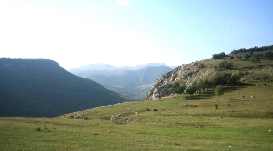
Natural monuments, rare plants, and animal species were widespread in the occupied region. The occupied mountainous zone of the Lesser Caucasus is a large forest area of Azerbaijan. The total forest area of the region was 246.7 thousand hectares.
In order to protect the natural landscape, the world of rare plants and animals in the territories of the Lesser Caucasus, which are now under occupation, a number of reserves have been created. And here you can name the Besitchay reserve, the Lachin reserve, etc. The Besitchay reserve was created in 1974 in the south-west of Azerbaijan, on the now occupied territory of Zangilan in the valley of the Besitchay river. The area of the reserve is 107 hectares. The protected object here is the eastern plane tree. The plane grove stretches along the river for a distance of 12 km. The existing trees are up to 500 years old. The eastern plane tree (plane tree) is listed in the "Red Book".
The Lachin reserve was established in 1961 on the territory of the now occupied Lachin. The area is 21.4 thousand hectares. In the reserve, the following are protected: mountain goat (about 400 heads), roe deer (500), steppe pig (400), turach (800), partridge (2500). Khary bulbul (broadleaf orchis), found in Azerbaijan only in the Shusha region, is considered to be a symbol of Karabakh.
The territories under occupation are rich in underground and surface natural resources. The most common minerals are non-ferrous metal ores, gold, mercury, chromite, perlite, lime, marble, agate, mineral waters, and others. The territory also has a wide resort and recreational potential.
Rare and valuable minerals are widespread in the occupied region. Significant reserves of copper-zinc ores are concentrated in the Mehman deposit located in the east of the Lesser Caucasus. The ore deposits, ready for exploitation, were studied here. Mercury reserves of industrial importance are located in the Shorbulag and Agyatag deposits of the Kelbajar region.
The occupied territories are rich in various types of building materials, which are of great importance for the construction and industry of Azerbaijan.
In the occupied territories, there are up to 120 deposits of mineral water of various compositions of great medicinal value. Among them, the greatest attention is attracted by Yukhars and Ashagi Istisu, Bagyrsag, Keshdak in the Kelbajar region; Ilygsu, Minkand in the Lachin region; Turshsu, Syrlan in the Shusha region and other mineral waters.
Mineral waters of Istisu, located on the territory of the Kelbajar region, are distinguished by a particularly favorable gas and chemical composition, high temperature, and large natural reserves. With these waters, it is possible to treat both internal and external human diseases.
In the 80s, a resort and a factory for the production of packed mineral water were built at the Istisu spring. This plant produced 800 thousand liters of water per day.
The mineral spring Turshsu has located 17 km from the city of Shusha in Azerbaijan. From time immemorial, the sources of Turshsu and Isa Bulagy have been a venue for musical and poetry meetings.
It should be noted that the occupied regions account for 39.6% of the total geological reserves of mineral waters in Azerbaijan.
One of the important conditions for the formation of national territory is the presence of close internal economic ties. Economic ties that arise within national territories are characterized by their historicity, stability, and constancy. The former Nagorno-Karabakh Autonomous Region, which Armenia currently claims, has always been part of Azerbaijan and was governed by its statehood. The center of the region (Khankendi) is directly and closely connected with the Azerbaijan railways and highways, the entire transport and communication system of the republic. The distance from this center by rail to Baku is 392 km.
Most of the Armenians of Nagorno-Karabakh had close ties with the city of Baku. Many members of their families worked and lived at a good socio-economic level in this city.
The ardent nationalist A. Mikoyan represented in the leadership of the Soviet state, bearing in mind the significant role of the factor of economic ties, wrote on 20 May 1920: “The Dashnaks, who are agents of the Armenian state, are trying to unite Karabakh with Armenia, however, this means depriving the population of Karabakh of their source of existence - Baku and forcibly connect with nothing that has no connection Erivanyu.
The aforementioned truths that in economic terms Nagorno-Karabakh has always been an integral and integral part of Azerbaijan, expressed by the Armenian leaders, are due to the geographical location and natural characteristics of this territory. So, over the centuries, the mountainous part of Karabakh developed in close economic ties with the low-lying Karabakh. The roads running along the river valleys tightly linked the two territories together economically. The occupation of Nagorno-Karabakh by the Armenians and its forcible separation from the low-lying Karabakh, in spite of all these historical and geographical realities, created very serious problems for the population and economy of the region.
For many years, most of the enterprises located on the territory of Nagorno-Karabakh operated on the basis of fuel, raw materials, and materials brought from the regions of Azerbaijan, many of them functioned as branches of large Baku enterprises.
The former Nagorno-Karabakh maintained comprehensive ties with Azerbaijan in the following areas:
1) cooperative relations of production, i.e. purely industrial ties, including fuel and raw materials; 2) commodity-money turnover; 3) material and technical support; 4) transport and cargo communications; 5) scientific and technical relations; 6) state and administrative relations; 7) cultural and educational ties, etc.
Thus, if we analyze each of the above links, we can present a real picture of Nagorno-Karabakh's stay in close connection with Azerbaijan. Suffice it to note that out of all the silkworm raw materials supplied in 1985 to the large silk mill of Karabakh in Khankendi, only 8% was produced in Nagorno-Karabakh itself. The rest 92% were brought from other regions of Azerbaijan. While of the volume of foreign economic relations of the Nagorno-Karabakh region carried out in 1986, only 0.3%, and 1.4% of imports came from the Armenian Republic, the share of its exports to Azerbaijan accounted for 33.3%, the share the same import was even higher.
The unified transport and communication system that operated for many years in the occupied regions has been destroyed as a result of the aggression of Armenia. The Nakhichevan Autonomous Republic, located outside the Karabakh zone and blocked by Armenia, also suffers from these devastations.
In terms of transport and communicatioфn, the territory of Nagorno-Karabakh is located much farther from the capital of Armenia, Yerevan, and other large economic centers; the mountain roads connecting them are not entirely favorable from the point of view of natural disasters and large-tonnage freight traffic.
Thus, all the regions under the occupation of Armenia were in close connection with Azerbaijan. The basis of this connection was the transport and communication systems and the economic trend. Therefore, the demands put forward proceeding from the principle of national self-determination in relation to Nagorno-Karabakh, which has always been an inseparable part of Azerbaijan from a socio-economic point of view, are groundless.
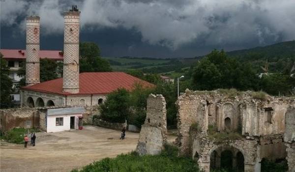
The invaders, who already consider the former capital of the historical Karabakh Khanate of Azerbaijan, Shusha to be appropriated, are destroying the city's valuable historical monuments, erasing the national architecture, and arranging it at their own discretion. Completely new military engineering structures are being built in the Lachin corridor of Azerbaijan.
The appropriation of the lands of Azerbaijan by Armenia using force and carrying out any kind of changes on them from the point of view of modern international law is considered unacceptable. From an international legal point of view, all resources located on this territory continue to be the property of Azerbaijan, this property is only temporarily considered under occupation and must be returned to its rightful owner - Azerbaijan.
All that has been said once again confirms that the obscuring of the Nagorno-Karabakh conflict with the words of exclusively the right of free self-determination of national minorities has no legal or socio-economic basis.