Azerbaijani regions around Karabakh
Azerbaijani districts around Nagorno-Karabakh are Kalbajar, Lachin, Aghdam, Fizuli, Jabrayil, Gubadli and Zangilan. This regions were under the occupation by Armenia, but Azerbaijani Armed Forces taking these regions back, which are primordial lands of Azerbaijan.
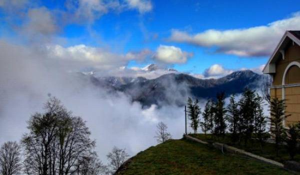
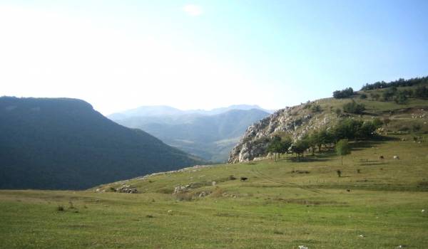
Kalbajar is the highest mountain region of Azerbaijan. The origin of the toponym "Kalbajar" in the ancient Turkic language means "castle on the river". Kalbajar is one of the oldest human settlements. Ancient settlements with a history of more than 30,000 years, 6,000-year-old rock carvings, and examples of the ancient Turkish alphabet in the form of straw were discovered in the Kalbajar area. The stone monuments were created in Northern Azerbaijan during the period of early Turkism, fire-worship, Christianity, and from the 7th century onwards during the spread of Islam.
Kalbajar region is located in the west of Azerbaijan, in the valley of the Tartar River, in the Greater Caucasus Mountains, at an altitude of 1500-3800 meters above sea level. The highest point is Jamishdag peak (Murovdag), 3724 meters above sea level. The main rivers flowing through the region are Tartar, Bazarchay, and their tributaries. Most of its territory is dominated by cold and mountainous tundra climates with dry winters. The region is bordered by Armenia in the west, Aghdam and Tartar in the east, Dashkasan, Goygol, and Goranboy districts in the north, and Lachin district and Khojaly city in the south.
The highest peaks are Mount Jamishdag (3724 m) and Dalidag (3616 m). Most of the area is forested. The region of Kalbajar is rich in minerals, including gold and chrome deposits. İmportant mercury reserves are industrially located in Shorbulag and Agyatag of the Kalbajar region. There are Alagoller, Garagol, Zalkha, and other lakes. The total area of forests is comprised of about 30,000 hectares.
There are a lot of historical monuments of the Albanian period in Kalbajar. The most famous of these is the Khudavang temple complex. The monument complex, also called "Khudadeng", was built in the VI-VII centuries by an Albanian prince, and this monument became a religious temple of the Albanian principality in the XV century. Later, the temple was repaired several times, added to, and finally rebuilt by the Albanian ruler Hassan Jalal.
Galaboynu fortress in Galaboynu village of Kalbajar region, Albanian temple in Vang village, Albanian church in Charakdar village, Lok fortress in Ganlikend village, Ulukhan fortress in Garachanli village, Jomard fortress in Jomard village, Albanian church located at the junction of Tartar river and Bulanig river, Keshickhi tower in Jamishli village, The mosque in the village Otagli, the Taglitash bridge over the Tartar River in the village of Soyugbulag, the Kalbajar Museum of History and Ethnography, the Ashiq Shamshir's House of Culture, and the shrine of Seyid Asadullah on the Soyudlu plateau were destroyed by the Armenian Armed Forces.
The region occupied by the Armed Forces of the Republic of Armenia in 1993, and finally, according to the tripartite Declaration signed on November 25, 2020, was liberated, the Armed Forces of the Republic of Azerbaijan entered the region and took control.
Lachin region is located in a mountainous area, in the south-west of the Republic of Azerbaijan. The highest point is the Gizilbogaz peak, located at an altitude of 3,594 meters above sea level. The climate is temperate continental. The main river flowing through its territory is Hakari. It is bordered to the north by Kalbajar, to the east by Khojaly, Shusha, and Khojavend, to the south by Gubadli, and to the west by Armenia.
Its area is considered to be having of the rarest trees in the world with red iron forests and is rich with many minerals springs, cobalt, uranium, mercury, gold, iron, marble deposits of different colors, mountains with many medicinal plants and so on.
Lachin region was established in 1924. Lachin was formerly called Abdallar, received city status in 1923, and was renamed Lachin in 1926. The center of the region is Lachin city.
Before the occupation, the area of the district was 1883 square meters. km., the population was 65,430 people. Lachin is an area with a rich historical past. The monuments of Lachin are valuable and unique, they can be compared to the caves of Azykh in the Khojavend region and Taglar caves in the Jabrayil region, which date back to the I-II millennium BC.
The art of weaving was developed in Lachin as well. The atchulu, palaz, kilim, carpet, zili, khurcun, farmesh woven here are distinguished by their special beauty. It is not accidental that the creation of the carpet known in the world as "Gasimushagi" is connected with the name of this region.
As a result of the occupation, 264 people were killed, 65 were taken hostage and 103 were disabled. There are 6 National Heroes of the region. Out of the 24,374 children aged 1 to 16 in the district, 18 were martyred, 225 were disabled, 1,071 were orphaned by one, and 31 by both parents.
Lachin region, occupied by the Armenian armed forces since May 18, 1992, was liberated from 28-year occupation on December 1, 2020, in accordance with the terms of the Tripartite Declaration signed by the Presidents of the Republic of Azerbaijan, the Russian Federation, and the Prime Minister of the Republic of Armenia.
The relief of the Fizuli region, having low mountains in the west, is mainly a sloping plain descending to the Araz River. The climate is semi-desert and dry steppe with dry summers in the eastern part and mild heat in the west. The rivers Kondalanchay, Guruchay, and Gozluchay belong to the Araz river basin flowing from the border of the Islamic Republic of Iran.
It borders with the Islamic Republic of Iran along the Jabrayil, Khojavend, Agjabadi, Beylagan districts, and the Araz River.
The territory of the Fuzuli region is 1386 km2 and the population is about 105,000 people.
The region was established as an administrative-territorial unit in 1827 and its original name was Garabulag. It was organized as a district on August 8, 1930, and was named Garyagin. In April 1959, in honor of the 400th anniversary of the great Azerbaijani poet Mohammad Fuzuli, the Garyagin district was renamed Fuzuli district.
At different times in the territory of the Fizuli region, researches were carried out in Garakopektepe, Garabulag mounds, Gunashtapa, Guruchay shores, and other places, it was proved that Azerbaijan has ancient roots. In the summer of 1968, the bones of the lower jaw of a pre-Neanderthal-Azykhantrop man were discovered by the late archaeologist Mammadali Huseynov in the Azykh cave, 15 km from the district center.
There were plenty of architectural monuments built under the influence of the Ajami school of architecture in the Fizuli region. Unfortunately, Ahmadalilar or Arghali tomb (late 13th century), Babi tomb (1273), Mirali tomb built of smooth stone in Ashagi Veysalli village (15th century), Hajigiyasaddin mosque in Gargabazar village (1682), Caravanserai (1684), a mosque in Gochahmedli village (XVIII century), Haji Alakbar mosque in Fuzuli (XIX century), "Mashadi Habib" bath (XIX century), ancient monuments of horse and ram figures carved from stone near Merdinli village (XVIII-XIX centuries) and so on. Such monuments of historical significance were savagely vandalized, destroyed, and burned by Armenians.
Fuzuli has more than 1,100 martyrs and casualties, 113 hostages, and 1,450 disabled people of various degrees. As a result of the Armenian aggression in Fizuli, 36,361 children were injured, 155 of them were orphaned. The weight of the war suffered mainly the population of Ashagi and Yukari Veysalli, Gajar, Juvarli, Yaglivand villages.
On August 23, 1993, 58 villages and districts, including the Fuzuli city, were occupied by Armenians, and about 55,000 Fuzuli people were expelled from their native lands. In 1995-1997, 40,000 civilians returned to the liberated territories of the Fuzuli region and restored their normal lives. The Azerbaijani Army liberated Horadiz village from the Armenian occupation On September 27. On October 17, 2020, the city of Fuzuli was completely liberated from the Armenian occupation by the Azerbaijani Army.
Gubadli region is located in the south-west of Azerbaijan, in the south-western foothills of the Karabakh range. The relief is foothills and mountains. The highest point is Topagach peak, 2003 m above sea level. The climate is temperate continental. The Bargushad and Hakari rivers flow through its territory. It is bordered by Lachin in the north, the Republic of Armenia in the west (120 km), Jabrayil in the west, and the Zangilan region in the south-west. It was established on March 14, 1933. The administrative center is Gubadli city, which is located on both banks of the Bargushad River.
The territory of the region is rich in ancient historical monuments. The temple in "Gavur gorge" of the IV century, the monuments of "Galali" and "Goygala" of the V century, the tomb of "Demirchiler" built in the XIV century, Haji Badal bridge, Lalazar bridge.
The nature of the Gubadli region is very beautiful. In 1969, a state reserve was established here. There are 13.2 thousand hectares of forest in the district. Unfortunately, according to current information, the forests of Gubadli are cut down by Armenians and transported to Armenia or abroad.
The territory of the region was occupied by the Armenian armed forces on August 31, 1993. On October 25, 2020, the brave Azerbaijani army liberated Gubadli city from the Armenian occupation.
Jabrayil is located in the south-east of the Lesser Caucasus Mountains, in the Geyan plain, and in the Karabakh range. The region borders the Islamic Republic of Iran along the Araz River in the south. It covers an area of 1,049 square kilometers and is mostly mountainous. The banks of the Araz River were once dense with Tugay forests.
The large villages of Jabrayil - Boyuk Marjanli, Soltanli, and others are located in the fertile lands along the Araz. The highest peak of the Jabrayil region is Mount Tumas (1580 m). Before the Armenian occupation, there were 14 large-diameter plane trees, 104 kahriz, and 99 springs in the region, aged 400-500.
According to sources and information, the toponym Jabrayil is associated with the name of the angel named Gabriel, who is closest to God in Islam and monotheistic religions. The word Gabriel means "servant of God" in Arabic.
On August 8, 1930, the Jabrayil district was formed with the village of Jabrayil, being the center of Jabrayil. The territory of the district within its current boundaries was 1050 km² and the population was 24,300 people.
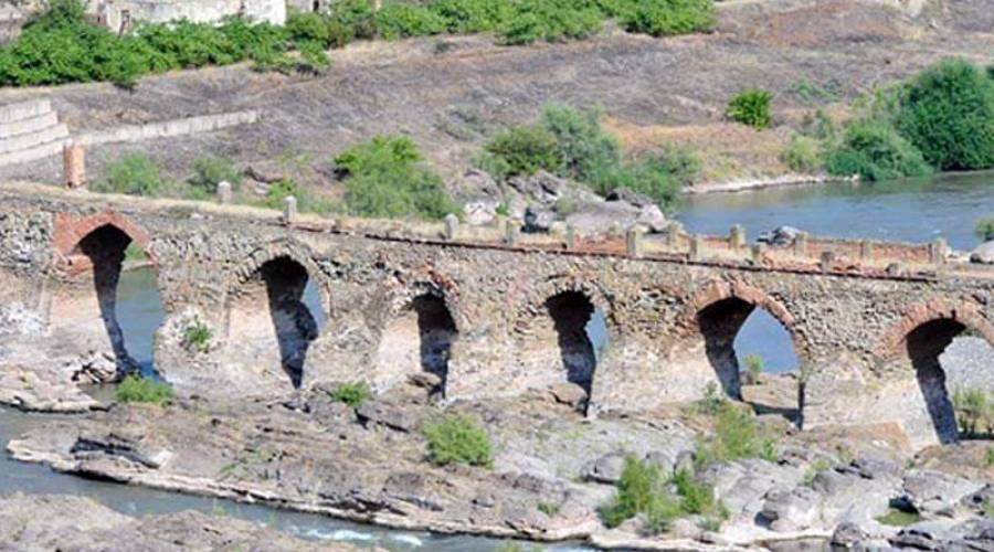
There were such historical monuments as Khudaferin Bridge with 11 spans - XI-XII centuries, Khudaferin Bridge with 15 spans - XIII centuries, many mounds of the Bronze Age and early Middle Ages, Neftali mounds, Agoglan necropolis, Jangulu mound, etc.
The region has been under occupation by the Armenian armed forces since August 23, 1993. As a result of the occupation, 347 people became shahids, and 172 were disabled. Many historical monuments were destroyed and looted by the Armenian occupiers.
On October 4, 2020, the center of the region and a number of villages were liberated from the Armenian occupation and reunited with the Azerbaijani lands.
Zangilan district is located in the Araz region of the Lesser Caucasus. The complex and fragmented relief is mainly medium and low mountains. The area has unique beauties, steep cliffs, tulip plains, eye-catching forests, and bushes. The territory of the region has a complex surface structure. The sharp mountain rivers Hakari, Okhchu, Basitchay, and Araz flow through its territory. The temperate climate is dominated by dry winters. It is bordered by Armenia to the west and northwest, Iran to the south and southwest, Gubadli to the north, and Jabrayil to the east.
Historically located at the crossroads of east and west, the region has been a major trading hub. The antiquity of the history of the region is proved by castles, observation posts, material and cultural monuments and samples found during archeological excavations, ancient coins, and household utensils.
According to the famous 14th-century geographer and historian Hamdullah Ghazvini, Zangilan was founded in the 15th year of the Hijri date, which means in 636. There was one city, 5 settlements (Agh Oyug, Minivan, Bartaz, Aghband, Hakari), and 79 villages in the Zangilan district.
One of the most famous architectural monuments in the region, rich in historical monuments, is the Shahri-Sharifan monument located in the village of Sharifan. Although a large part of this monument was washed away by the floods of the Hakari River, part of the tomb has reached us. This complex, which is the most valuable monument in the medieval architecture of Azerbaijan, belongs to the XII-XIII centuries.
The tomb in Mammadbeyli village of the region is one of the monuments that has survived to the present day.
The circular tower of the 14th century in the village of Hajallı - this historical architectural monument was also preserved. Unfortunately, we do not have a picture or information about him. The exact date of construction of this tower is unknown. There was also a medieval kahriz, the remains of a caravanserai, and a mosque.
This mosque in the center of the district belongs to the XVII-XVIII centuries. The mosque is believed to have been built during the Safavid period. Yenikend Tomb was also a 14th-century tomb in Yenikend village on the right bank of the Hakari.
The territory of the region was occupied by the Armenian armed forces on October 1, 1993. As a result of the occupation, 191 people became shahids.
On October 20, 2020, the city of Zangilan was liberated from the Armenian occupation by the Azerbaijani Armed Forces.
Aghdam region is located in the center of Karabakh, the ancient, charming land of Azerbaijan - in the north-eastern foothills of the Karabakh mountain range, west of the Kur-Araz lowland. The relief is mostly plain, partly mountainous. The Gargar and Kachin rivers flow through the region. It is bordered by Tartar and Barda districts in the north, Khojavend district in the south, Agjabedi district in the east, and Kalbajar district and Khojaly city in the west. The largest settlements are Marzili, Seyidli, Giyasli, Khidirli, and Zangishali villages.
According to some sources, the word "Aghdam" means "small fortress" in the ancient Turkic language. In the first half of the XVIII century, the founder of the Karabakh khanate Panahali khan ordered to build a white stone palace for himself in this city. This building has long been a kind of landmark for the residents of the surrounding villages. In this sense, "Aghdam" has a meaning of a bright, white house radiated by the rays of the sun.
Since the beginning of the events in Nagorno-Karabakh, Aghdam has been the center of the occurred events here.
Armenia, which established its existing state on the lands of ancient Azerbaijan, started a war in February 1988 in order to occupy a new territory of Azerbaijan - Nagorno-Karabakh, which firstly involved Aghdam, and the heavy burden from the first day of the event fell upon Aghdam region and its people.
On July 4, 1993, Armenian forces bombed Aghdam with artillery, destroying most of the city. As a result of the military aggression that lasted until May 12, 1994, the Armenians managed to occupy 846.7 square kilometers of the territory of the Aghdam region, which comprises 77.4 percent of the total area. 5897 martyrs, 3531 invalids, and 1871 orphans were killed in the bloody battles for the defense of Aghdam that lasted for more than 5 years. Thousands of people were injured and more than 126,000 people were displaced from their homes.
On July 23, 1993, the city of Agdam was occupied by the Armenian army. On November 20, 2020, according to the terms of the Nagorno-Karabakh ceasefire declaration, the Azerbaijani Armed Forces will enter the city of Agdam. This puts an end to the occupation of Aghdam.